
Garsella topographic map
Interactive map
Click on the map to display elevation.
About this map
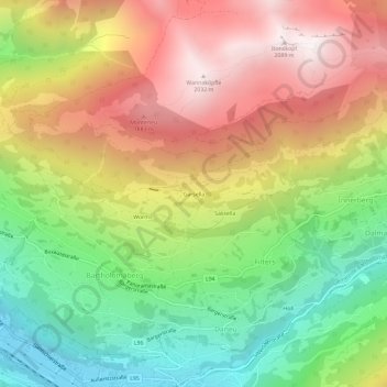
Name: Garsella topographic map, elevation, terrain.
Average elevation: 1,315 m
Minimum elevation: 647 m
Maximum elevation: 2,055 m
Other topographic maps
Click on a map to view its topography, its elevation and its terrain.
Sassella
Österreich > Vorarlberg > Bezirk Bludenz > Gemeinde Bartholomäberg > Filters
Sassella, Filters, Gemeinde Bartholomäberg, Bezirk Bludenz, Vorarlberg, 6781, Österreich
Average elevation: 1,295 m