
Bonstetten topographic map
Interactive map
Click on the map to display elevation.
About this map
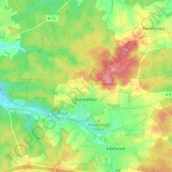
Name: Bonstetten topographic map, elevation, terrain.
Average elevation: 513 m
Minimum elevation: 461 m
Maximum elevation: 579 m
Other topographic maps
Click on a map to view its topography, its elevation and its terrain.
Gersthofen
Deutschland > Bayern > Landkreis Augsburg
Gersthofen, Landkreis Augsburg, Bayern, 86368, Deutschland
Average elevation: 466 m
Straßberg
Deutschland > Bayern > Landkreis Augsburg > Bobingen
Straßberg, Bobingen, Landkreis Augsburg, Bayern, 86399, Deutschland
Average elevation: 538 m
Lettenbach
Deutschland > Bayern > Landkreis Augsburg > Diedorf
Lettenbach, Diedorf, Landkreis Augsburg, Bayern, 86420, Deutschland
Average elevation: 496 m
Welden
Deutschland > Bayern > Landkreis Augsburg
Welden, Landkreis Augsburg, Bayern, 86465, Deutschland
Average elevation: 497 m