
Make a donation
Gear up for your next adventure:
As an Amazon Associate, this site earns from qualifying purchases at no extra cost to you.
Sandy Bay topographic map
Click on the map to display elevation.
Make a donation
Gear up for your next adventure:
As an Amazon Associate, this site earns from qualifying purchases at no extra cost to you.
About this map
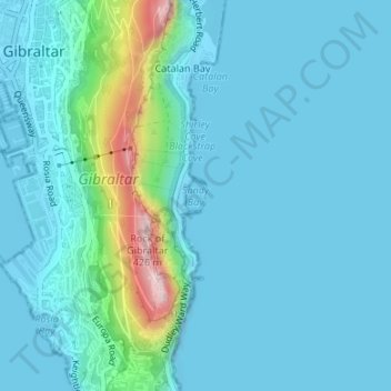
Name: Sandy Bay topographic map, elevation, terrain.
Location: Sandy Bay, Gibraltar (36.12966 -5.34114 36.13190 -5.33938)
Average elevation: 53 m
Minimum elevation: -2 m
Maximum elevation: 404 m
Make a donation
Gear up for your next adventure:
As an Amazon Associate, this site earns from qualifying purchases at no extra cost to you.
Other topographic maps
Click on a map to view its topography, its elevation and its terrain.
Rock of Gibraltar
The Rock of Gibraltar forms a peninsula jutting out into the Strait of Gibraltar from the southern coast of Spain. The promontory is linked to the continent by means of a sandy tombolo with a maximum elevation of 3 m (9.8 ft). To the north, the Rock rises vertically from sea level up to 411.5 m (1,350 ft) at…
Average elevation: 47 m