
Castelló d'Empúries topographic map
Interactive map
Click on the map to display elevation.
About this map
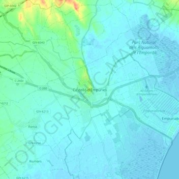
Name: Castelló d'Empúries topographic map, elevation, terrain.
Average elevation: 6 m
Minimum elevation: -2 m
Maximum elevation: 43 m
Other topographic maps
Click on a map to view its topography, its elevation and its terrain.
Castelló d'Empúries
Spanje > Catalonië > Alt Empordà > Castelló d'Empúries
Castelló d'Empúries, Alt Empordà, Gerona, Catalonië, 17486, Spanje
Average elevation: 6 m