
Cincinnati topographic map
Click on the map to display elevation.
Cincinnati
Cincinnati has several standard modes of transportation including sidewalks, roads, public transit, bicycle paths and airports. The city's hills preclude the regular street grid common to many cities built up in the 19th century, and outside of the downtown basin, regular street grids are rare except for in patches of flat land where they are small and oriented according to topography.
About this map
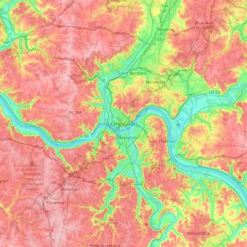
Name: Cincinnati topographic map, elevation, terrain.
Location: Cincinnati, Hamilton County, Ohio, 45202, United States (38.94145 -84.67246 39.26145 -84.35246)
Average elevation: 225 m
Minimum elevation: 139 m
Maximum elevation: 293 m
Other topographic maps
Click on a map to view its topography, its elevation and its terrain.
Cincinnati
United States > Ohio > Hamilton County
Cincinnati has several standard modes of transportation including sidewalks, roads, public transit, bicycle paths and airports. The city's hills preclude the regular street grid common to many cities built up in the 19th century, and outside of the downtown basin, regular street grids are rare except for in…
Average elevation: 222 m
Cincinnati
United States > Ohio > Hamilton County
Cincinnati features a distinctive topography characterized by its rolling hills and valleys. The city is situated on the north bank of the Ohio River, where the terrain rises sharply from the riverfront, reaching elevations of approximately 980 feet (299 meters) in some areas. The average elevation throughout…
Average elevation: 222 m
Norwood
United States > Ohio > Hamilton County
The earliest humans in the area now known as Norwood are believed to have been Pre-Columbian era people of the Adena culture. Norwood Mound, a prehistoric earthwork mound built by the Adena, is located in Norwood and listed on the National Register of Historic Places. The Adena constructed the mound at the…
Average elevation: 196 m
Loveland
United States > Ohio > Hamilton County
According to the United States Census Bureau, the city has a total area of 5.00 square miles (12.95 km2), of which 4.93 square miles (12.77 km2) is land and 0.07 square miles (0.18 km2) is water. The city is situated at an elevation of 597 ft (182 m) above sea level.
Average elevation: 222 m
Nature Center at The Summit
United States > Ohio > Hamilton County > Cincinnati
Average elevation: 173 m
Covedale Gardens
United States > Ohio > Hamilton County > Cincinnati > Covedale
Average elevation: 268 m
Loveland
United States > Ohio > Hamilton County
According to the United States Census Bureau, the city has a total area of 5.00 square miles (12.95 km2), of which 4.93 square miles (12.77 km2) is land and 0.07 square miles (0.18 km2) is water. The city is situated at an elevation of 597 ft (182 m) above sea level.
Average elevation: 222 m
Nature Center at The Summit
United States > Ohio > Hamilton County > Cincinnati
Average elevation: 173 m
Cincinnati
United States > Ohio > Hamilton County
Cincinnati has several standard modes of transportation including sidewalks, roads, public transit, bicycle paths and airports. The city's hills preclude the regular street grid common to many cities built up in the 19th century, and outside of the downtown basin, regular street grids are rare except for in…
Average elevation: 222 m
Camp John McLean Memorial Park
United States > Ohio > Hamilton County > Wyoming > Park Place
Average elevation: 207 m
Cincinnati
United States > Ohio > Hamilton County
Cincinnati has several standard modes of transportation including sidewalks, roads, public transit, bicycle paths and airports. The city's hills preclude the regular street grid common to many cities built up in the 19th century, and outside of the downtown basin, regular street grids are rare except for in…
Average elevation: 222 m
French Park
United States > Ohio > Hamilton County > Amberley Village > Rolling Knolls Estate
Average elevation: 235 m
Norwood
United States > Ohio > Hamilton County
The earliest humans in the area now known as Norwood are believed to have been Pre-Columbian era people of the Adena culture. Norwood Mound, a prehistoric earthwork mound built by the Adena, is located in Norwood and listed on the National Register of Historic Places. The Adena constructed the mound at the…
Average elevation: 196 m
Cincinnati
United States > Ohio > Hamilton County
Cincinnati has several standard modes of transportation including sidewalks, roads, public transit, bicycle paths and airports. The city's hills preclude the regular street grid common to many cities built up in the 19th century, and outside of the downtown basin, regular street grids are rare except for in…
Average elevation: 222 m