Hellshire topographic map
Interactive map
Click on the map to display elevation.
About this map
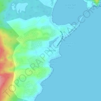
Name: Hellshire topographic map, elevation, terrain.
Location: Hellshire, Saint Catherine, Middlesex County, Jamaica (17.87957 -76.91697 17.91957 -76.87697)
Average elevation: 16 m
Minimum elevation: 0 m
Maximum elevation: 103 m
Other topographic maps
Click on a map to view its topography, its elevation and its terrain.
Guanaboa Vale
Guanaboa Vale, Saint Catherine, Middlesex County, Jamaica
Average elevation: 182 m
Bog Walk
Bog Walk, Saint Catherine, Middlesex County, Jamaica
Average elevation: 150 m
Time And Patience
Time And Patience, Saint Catherine, Middlesex County, Jamaica
Average elevation: 144 m
Montpelier
Jamaica > Saint Catherine > Spanish Town
Montpelier, Spanish Town, Saint Catherine, Middlesex County, Jamaica
Average elevation: 543 m
Portmore
Portmore, Saint Catherine, Middlesex County, Jamaica
Average elevation: 148 m
Spanish Town
Spanish Town, Saint Catherine, Middlesex County, Jamaica
Average elevation: 136 m