
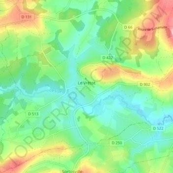
Le Vrétot topographic map
Interactive map
Click on the map to display elevation.
About this map
Name: Le Vrétot topographic map, elevation, terrain.
Average elevation: 61 m
Minimum elevation: 17 m
Maximum elevation: 145 m
Other topographic maps
Click on a map to view its topography, its elevation and its terrain.
Hôtel Lagnel
France > Normandie > Manche > Bricquebec-en-Cotentin > Le Vrétot
Hôtel Lagnel, Le Vrétot, Bricquebec-en-Cotentin, Cherbourg, Manche, Normandie, France métropolitaine, 50260, France
Average elevation: 56 m