
Ranch topographic map
Click on the map to display elevation.
About this map
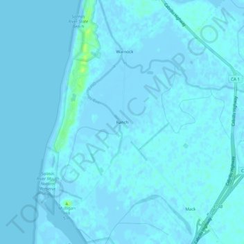
Name: Ranch topographic map, elevation, terrain.
Location: Ranch, Monterey County, California, 95012, United States (36.74251 -121.80829 36.78251 -121.76829)
Average elevation: 1 m
Minimum elevation: -4 m
Maximum elevation: 14 m
Other topographic maps
Click on a map to view its topography, its elevation and its terrain.
Monterey
United States > California > Monterey County
During winter, snow occasionally falls in the higher elevations of the Santa Lucia Mountains and Gabilan Mountains that overlook Monterey, but snow in Monterey itself is extremely rare. A few unusual events in January 1962, February 1976, and December 1997 brought a light coating of snow to Monterey. In March…
Average elevation: 50 m
Marina
United States > California > Monterey County
Marina is a city in Monterey County, California, United States. The United States Census Bureau estimated its 2018 population at 22,535. Marina is located along the central coast of California, 8 miles (13 km) west of Salinas, and 8 miles north of Monterey. Marina is also connected to Monterey, California by…
Average elevation: 17 m
Pacific Grove
United States > California > Monterey County
Pacific Grove, situated on the northern tip of the Monterey Peninsula in California, showcases a varied and picturesque topography that is characterized by its rugged coastal cliffs and rolling hills. The area features a blend of sandy beaches, such as Asilomar State Beach and Lovers Point Beach, which are…
Average elevation: 14 m
Salinas
United States > California > Monterey County
Prior to mass agricultural and urban development, much of the city consisted of rolling hills bisected by wooded creeks and interspersed with marsh land. Today, the city is located mostly on leveled ground, with some rolling hills and wooded gulches with creeks remaining in the north-eastern Creekbridge and…
Average elevation: 19 m
Seaside
United States > California > Monterey County
Seaside, formerly East Monterey, is a city in Monterey County, California, United States, with a population of 32,366 as of the 2020 census. It is located 2.25 miles (3.6 km) east-northeast of Monterey, at an elevation of 33 feet (10 m), and is the home of California State University, Monterey Bay (CSUMB), UC…
Average elevation: 69 m
King City
United States > California > Monterey County
King City (variants: Kings City, City of King) is a city in Monterey County, California, United States. It is located on the Salinas River 51 miles (82 km) southeast of Salinas, at an elevation of 335 feet (102 m). It lies along U.S. Route 101 in the Salinas Valley of California's Central Coast. King City is a…
Average elevation: 103 m
David Cutino Park
United States > California > Monterey County > Seaside > Del Monte Heights
Average elevation: 35 m
Point Lobos State Natural Reserve
United States > California > Monterey County > Carmel Highlands
Average elevation: 21 m
Salinas
United States > California > Monterey County
Prior to mass agricultural and urban development, much of the city consisted of rolling hills bisected by wooded creeks and interspersed with marsh land. Today, the city is located mostly on leveled ground, with some rolling hills and wooded gulches with creeks remaining in the north-eastern Creekbridge and…
Average elevation: 19 m
Monterey
United States > California > Monterey County
Summers in Monterey are often cool and foggy. The cold surface waters cause even summer nights to be unusually cool for the latitude; this is in distinct contrast to the much warmer summer days and nights of the U.S. east coast. The extreme moderation of summer temperatures is further underlined by the fact…
Average elevation: 50 m
Moss Landing
United States > California > Monterey County > Moss Landing > Thompson
Moss Landing, formerly Moss, is an unincorporated community and census-designated place (CDP) in Monterey County, California, United States. As of the 2020 census, Moss Landing had a population of 237. It is located 18 miles (29 km) north-northeast of Monterey, at an elevation of 10 feet (3.048 m). It is on…
Average elevation: 1 m
Seaside
United States > California > Monterey County
Seaside, formerly East Monterey, is a city in Monterey County, California, United States, with a population of 32,366 as of the 2020 census. It is located 2.25 miles (3.6 km) east-northeast of Monterey, at an elevation of 33 feet (10 m), and is the home of California State University, Monterey Bay (CSUMB), UC…
Average elevation: 69 m
Fort Ord National Monument
United States > California > Monterey County > Seaside
Average elevation: 121 m
Monterey
United States > California > Monterey County
During winter, snow occasionally falls in the higher elevations of the Santa Lucia Mountains and Gabilan Mountains that overlook Monterey, but snow in Monterey itself is extremely rare. A few unusual events in January 1962, February 1976, and December 1997 brought a light coating of snow to Monterey. In March…
Average elevation: 50 m
King City
United States > California > Monterey County
King City (variants: Kings City, City of King) is a city in Monterey County, California, United States. It is located on the Salinas River 51 miles (82 km) southeast of Salinas, at an elevation of 335 feet (102 m). It lies along U.S. Route 101 in the Salinas Valley of California's Central Coast. King City is a…
Average elevation: 103 m
Salinas
United States > California > Monterey County
Prior to mass agricultural and urban development, much of the city consisted of rolling hills bisected by wooded creeks and interspersed with marsh land. Today, the city is located mostly on leveled ground, with some rolling hills and wooded gulches with creeks remaining in the north-eastern Creekbridge and…
Average elevation: 19 m
Las Lomas
United States > California > Monterey County > Las Lomas > Hutchings Gate
Las Lomas (Spanish for 'The Hills') is an unincorporated community and census-designated place (CDP) in Monterey County, California, United States. Las Lomas is located 7 miles (11 km) north-northwest of Prunedale. The elevation is 43 feet (13 m). The population was 3,046 at the 2020 census.
Average elevation: 35 m
Monterey
United States > California > Monterey County
Summers in Monterey are often cool and foggy. The cold surface waters cause even summer nights to be unusually cool for the latitude; this is in distinct contrast to the much warmer summer days and nights of the U.S. east coast. The extreme moderation of summer temperatures is further underlined by the fact…
Average elevation: 50 m
Seaside
United States > California > Monterey County
Seaside, formerly East Monterey, is a city in Monterey County, California, United States, with a population of 32,366 as of the 2020 census. It is located 2.25 miles (3.6 km) east-northeast of Monterey, at an elevation of 33 feet (10 m), and is the home of California State University, Monterey Bay (CSUMB), UC…
Average elevation: 69 m
Monterey
United States > California > Monterey County
Summers in Monterey are often cool and foggy. The cold surface waters cause even summer nights to be unusually cool for the latitude; this is in distinct contrast to the much warmer summer days and nights of the U.S. east coast. The extreme moderation of summer temperatures is further underlined by the fact…
Average elevation: 50 m
Prunedale
United States > California > Monterey County
Prunedale is a unincorporated community in Monterey County, California, United States. It is located 8 miles (13 km) north of Salinas at an elevation of 92 feet (28 m). The population was 18,885 as of the 2020 census, up from 17,560 in 2010. For statistical purposes, the United States Census Bureau has defined…
Average elevation: 104 m
Point Sur Lighthouse
United States > California > Monterey County > Big Sur Village
Average elevation: 11 m
Prunedale
United States > California > Monterey County
Prunedale is a unincorporated community in Monterey County, California, United States. It is located 8 miles (13 km) north of Salinas at an elevation of 92 feet (28 m). The population was 18,885 as of the 2020 census, up from 17,560 in 2010. For statistical purposes, the United States Census Bureau has defined…
Average elevation: 81 m
Sand City
United States > California > Monterey County
Sand City is a city in Monterey County, California, United States, located on the shores of Monterey Bay, and surrounded on most sides by the larger city of Seaside. Sand City is located 2 miles (3 km) northeast of Monterey, at an elevation of 72 feet (22 m). The population was 325 at the 2020 census. The city…
Average elevation: 11 m
Carmel Pinnacles State Marine Reserve
United States > California > Monterey County > Del Monte Forest
Average elevation: 2 m
King City
United States > California > Monterey County
King City (variants: Kings City, City of King) is a city in Monterey County, California, United States. It is located on the Salinas River 51 miles (82 km) southeast of Salinas, at an elevation of 335 feet (102 m). It lies along U.S. Route 101 in the Salinas Valley of California's Central Coast. King City is a…
Average elevation: 102 m
Salinas
United States > California > Monterey County
Prior to mass agricultural and urban development, much of the city consisted of rolling hills bisected by wooded creeks and interspersed with marsh land. Today, the city is located mostly on leveled ground, with some rolling hills and wooded gulches with creeks remaining in the north-eastern Creekbridge and…
Average elevation: 19 m