
Biscay topographic map
Interactive map
Click on the map to display elevation.
About this map
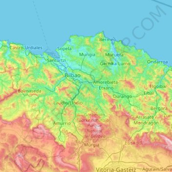
Name: Biscay topographic map, elevation, terrain.
Location: Biscay, Autonomous Community of the Basque Country, Spain (42.96872 -3.45035 43.45686 -2.41272)
Average elevation: 333 m
Minimum elevation: -2 m
Maximum elevation: 1,478 m
Other topographic maps
Click on a map to view its topography, its elevation and its terrain.
Hondarribia
Spain > Autonomous Community of the Basque Country > Bidasoa Beherea / Bajo Bidasoa
Hondarribia, Bidasoa Beherea / Bajo Bidasoa, Gipuzkoa, Autonomous Community of the Basque Country, 20280, Spain
Average elevation: 37 m
San Sebastián
Spain > Autonomous Community of the Basque Country
San Sebastián, Gipuzkoa, Autonomous Community of the Basque Country, Spain
Average elevation: 120 m
Urretxu
Spain > Autonomous Community of the Basque Country
Urretxu, Gipuzkoa, Autonomous Community of the Basque Country, Spain
Average elevation: 460 m
Santa Barbara
Spain > Autonomous Community of the Basque Country > Hernani > Sorgintxulo
Santa Barbara, GI-2132, Portu, Sorgintxulo, Hernani, Gipuzkoa, Autonomous Community of the Basque Country, 20120, Spain
Average elevation: 68 m
Azpeitia
Spain > Autonomous Community of the Basque Country > Urola-Kosta
Azpeitia, Urola-Kosta, Gipuzkoa, Autonomous Community of the Basque Country, 20730, Spain
Average elevation: 395 m
Nanclares de la Oca/Langraiz Oka
Spain > Autonomous Community of the Basque Country > Añanako kuadrilla/Cuadrilla de Añana
Nanclares de la Oca/Langraiz Oka, Iruña Oka/Iruña de Oca, Añanako kuadrilla/Cuadrilla de Añana, Álava, Autonomous Community of the Basque Country, 01230, Spain
Average elevation: 613 m
Libiki
Spain > Autonomous Community of the Basque Country > Dima
Libiki, Dima, Biscay, Autonomous Community of the Basque Country, 48141, Spain
Average elevation: 188 m
Karakate
Spain > Autonomous Community of the Basque Country > Debabarrena > Soraluze
Karakate, Soraluze, Debabarrena, Gipuzkoa, Autonomous Community of the Basque Country, 20590, Spain
Average elevation: 366 m
Barakaldo
Spain > Autonomous Community of the Basque Country
Barakaldo, Biscay, Autonomous Community of the Basque Country, Spain
Average elevation: 127 m
Monterredondo
Spain > Autonomous Community of the Basque Country > Añanako kuadrilla/Cuadrilla de Añana
Monterredondo, Valdegovía/Gaubea, Añanako kuadrilla/Cuadrilla de Añana, Álava, Autonomous Community of the Basque Country, Spain
Average elevation: 875 m
Buruntza Auzoa
Spain > Autonomous Community of the Basque Country > Andoain
Buruntza Auzoa, Andoain, Gipuzkoa, Autonomous Community of the Basque Country, 20140, Spain
Average elevation: 143 m
Getxo
Spain > Autonomous Community of the Basque Country > Andraka
Getxo, Andraka, Biscay, Autonomous Community of the Basque Country, 48620, Spain
Average elevation: 36 m
Vitoria-Gasteiz
Spain > Autonomous Community of the Basque Country > Gasteizko kuadrilla/Cuadrilla de Vitoria
Vitoria-Gasteiz, Gasteizko kuadrilla/Cuadrilla de Vitoria, Álava, Autonomous Community of the Basque Country, Spain
Average elevation: 626 m
Ugao-Miraballes
Spain > Autonomous Community of the Basque Country
Ugao-Miraballes, Biscay, Autonomous Community of the Basque Country, 48490, Spain
Average elevation: 189 m
Mungia
Spain > Autonomous Community of the Basque Country > Andraka
Mungia, Andraka, Biscay, Autonomous Community of the Basque Country, 48620, Spain
Average elevation: 111 m
Errenteria
Spain > Autonomous Community of the Basque Country > Donostialdea
Errenteria, Donostialdea, Gipuzkoa, Autonomous Community of the Basque Country, 20100, Spain
Average elevation: 190 m
Oyón/Oion
Spain > Autonomous Community of the Basque Country > Arabako Errioxa/Rioja Alavesa
Oyón/Oion, Arabako Errioxa/Rioja Alavesa, Álava, Autonomous Community of the Basque Country, 01320, Spain
Average elevation: 572 m
Bilbao
Spain > Autonomous Community of the Basque Country
Bilbao, Biscay, Autonomous Community of the Basque Country, Spain
Average elevation: 156 m
Armiñón
Spain > Autonomous Community of the Basque Country > Añanako kuadrilla/Cuadrilla de Añana
Armiñón, Añanako kuadrilla/Cuadrilla de Añana, Álava, Autonomous Community of the Basque Country, 01220, Spain
Average elevation: 520 m
Eibar
Spain > Autonomous Community of the Basque Country > Debabarrena
Eibar, Debabarrena, Gipuzkoa, Autonomous Community of the Basque Country, 20600, Spain
Average elevation: 367 m
Ea
Spain > Autonomous Community of the Basque Country
Ea, Biscay, Autonomous Community of the Basque Country, 48287, Spain
Average elevation: 104 m
Plaza de Larrazábal
Spain > Autonomous Community of the Basque Country > Bilbao
Plaza de Larrazábal, Zurbaran-Arabella, Uribarri, Bilbao, Biscay, Autonomous Community of the Basque Country, Spain
Average elevation: 101 m
Ermua
Spain > Autonomous Community of the Basque Country
Ermua, Biscay, Autonomous Community of the Basque Country, 48260, Spain
Average elevation: 332 m
Irun
Spain > Autonomous Community of the Basque Country > Bidasoa Beherea / Bajo Bidasoa
Irun, Bidasoa Beherea / Bajo Bidasoa, Gipuzkoa, Autonomous Community of the Basque Country, Spain
Average elevation: 163 m
Dima
Spain > Autonomous Community of the Basque Country > Dima
Dima, Biscay, Autonomous Community of the Basque Country, 48141, Spain
Average elevation: 501 m
Zarautz
Spain > Autonomous Community of the Basque Country > Urola-Kosta > Zarautz
Zarautz, Urola-Kosta, Gipuzkoa, Autonomous Community of the Basque Country, 20800, Spain
Average elevation: 127 m
Zaldibar
Spain > Autonomous Community of the Basque Country > Zaldibar > Zaldibar
Zaldibar, Biscay, Autonomous Community of the Basque Country, 48250, Spain
Average elevation: 305 m
Oñati
Spain > Autonomous Community of the Basque Country > Debagoiena > Oñati
Oñati, Debagoiena, Gipuzkoa, Autonomous Community of the Basque Country, 20560, Spain
Average elevation: 488 m
Santurtzi
Spain > Autonomous Community of the Basque Country > Santurtzi
Santurtzi, Biscay, Autonomous Community of the Basque Country, 48980, Spain
Average elevation: 34 m
Gautegiz Arteaga
Spain > Autonomous Community of the Basque Country > Gautegiz Arteaga > Gautegiz Arteaga
Gautegiz Arteaga, Biscay, Autonomous Community of the Basque Country, 48314, Spain
Average elevation: 104 m
Portugalete
Spain > Autonomous Community of the Basque Country > Portugalete
Portugalete, Biscay, Autonomous Community of the Basque Country, 48920, Spain
Average elevation: 33 m
Maturana
Spain > Autonomous Community of the Basque Country > Arabako lautada/Llanada Alavesa
Maturana, Barrundia, Arabako lautada/Llanada Alavesa, Álava, Autonomous Community of the Basque Country, Spain
Average elevation: 562 m
Legazpi
Spain > Autonomous Community of the Basque Country
Legazpi, Gipuzkoa, Autonomous Community of the Basque Country, Spain
Average elevation: 548 m
Lekeitio
Spain > Autonomous Community of the Basque Country
Lekeitio, Biscay, Autonomous Community of the Basque Country, 48280, Spain
Average elevation: 60 m
Elgoibar
Spain > Autonomous Community of the Basque Country > Debabarrena > Elgoibar
Elgoibar, Debabarrena, Gipuzkoa, Autonomous Community of the Basque Country, Spain
Average elevation: 321 m
Guernica
Spain > Autonomous Community of the Basque Country
Guernica, Biscay, Autonomous Community of the Basque Country, 48300, Spain
Average elevation: 68 m
Kortezubi
Spain > Autonomous Community of the Basque Country > Kortezubi
Kortezubi, Biscay, Autonomous Community of the Basque Country, 48315, Spain
Average elevation: 89 m
Somo
Spain > Autonomous Community of the Basque Country
Somo, Erriberagoitia/Ribera Alta, Añanako kuadrilla/Cuadrilla de Añana, Álava, Autonomous Community of the Basque Country, 01420, Spain
Average elevation: 768 m
Soil
Spain > Autonomous Community of the Basque Country > Montaña Alavesa/Arabako Mendialdea
Soil, Arraia-Maeztu, Montaña Alavesa/Arabako Mendialdea, Álava, Autonomous Community of the Basque Country, 01207, Spain
Average elevation: 898 m
Álava
Spain > Autonomous Community of the Basque Country
Álava, Autonomous Community of the Basque Country, Spain
Average elevation: 597 m
Elburgo/Burgelu
Spain > Autonomous Community of the Basque Country > Elburgo/Burgelu
Elburgo/Burgelu, Arabako lautada/Llanada Alavesa, Álava, Autonomous Community of the Basque Country, Spain
Average elevation: 616 m
Ibarra
Spain > Autonomous Community of the Basque Country > Tolosaldea
Ibarra, Tolosaldea, Gipuzkoa, Autonomous Community of the Basque Country, 20400, Spain
Average elevation: 259 m
Loiu
Spain > Autonomous Community of the Basque Country > Andraka
Loiu, Andraka, Biscay, Autonomous Community of the Basque Country, 48620, Spain
Average elevation: 70 m
Lalastra
Spain > Autonomous Community of the Basque Country > Añanako kuadrilla/Cuadrilla de Añana
Lalastra, Valderejo, Valdegovía/Gaubea, Añanako kuadrilla/Cuadrilla de Añana, Álava, Autonomous Community of the Basque Country, Spain
Average elevation: 947 m
Urduliz
Spain > Autonomous Community of the Basque Country > Andraka
Urduliz, Andraka, Biscay, Autonomous Community of the Basque Country, 48620, Spain
Average elevation: 90 m
Plentzia
Spain > Autonomous Community of the Basque Country > Andraka
Plentzia, Andraka, Biscay, Autonomous Community of the Basque Country, 48620, Spain
Average elevation: 61 m
Gipuzkoa
Spain > Autonomous Community of the Basque Country
Gipuzkoa, Autonomous Community of the Basque Country, Spain
Average elevation: 396 m