
Thank you for supporting this site ❤️
Make a donation
Make a donation
Gear up for your next adventure:
As an Amazon Associate, this site earns from qualifying purchases at no extra cost to you.
Cutervo topographic map
Click on the map to display elevation.
Thank you for supporting this site ❤️
Make a donation
Make a donation
Gear up for your next adventure:
As an Amazon Associate, this site earns from qualifying purchases at no extra cost to you.
About this map
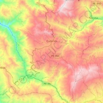
Name: Cutervo topographic map, elevation, terrain.
Location: Cutervo, Province of Cutervo, Cajamarca, Peru (-6.55007 -78.99521 -6.26666 -78.71100)
Average elevation: 2,429 m
Minimum elevation: 1,289 m
Maximum elevation: 3,500 m
Thank you for supporting this site ❤️
Make a donation
Make a donation
Gear up for your next adventure:
As an Amazon Associate, this site earns from qualifying purchases at no extra cost to you.