Geolocate

Blackpool topographic map

Click on the map to display elevation.

About this map

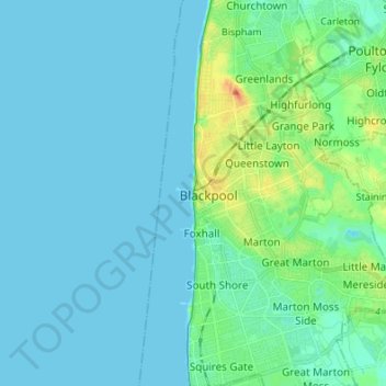
Name: Blackpool topographic map, elevation, terrain.

Location: Blackpool, Borough of Blackpool, Lancashire, England, FY1 1DL, United Kingdom (53.77794 -3.09098 53.85794 -3.01098)

Average elevation: 7 m

Minimum elevation: -2 m

Maximum elevation: 39 m

Borough of Blackpool trails, hiking, mountain biking, running and outdoor activities

Other topographic maps

Click on a map to view its topography, its elevation and its terrain.

Gear up for your next adventure:

📱Rugged Phone Cases - Heavy-duty protection for smartphones used as secondary GPS tools
🧼Camping Hygiene Kits - Compact hygiene essentials for outdoor stays
🔋Solar Chargers - Eco-friendly charging solutions for outdoor use
🔥Reusable Hand Warmers - Maintain dexterity in your fingers for precise map handling
🔋Solar Power Banks - Keep your GPS and phone charged during multi-day expeditions

As an Amazon Associate, this site earns from qualifying purchases at no extra cost to you.