
Bear Run topographic map
Interactive map
Click on the map to display elevation.
About this map
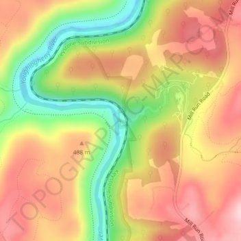
Name: Bear Run topographic map, elevation, terrain.
Average elevation: 450 m
Minimum elevation: 312 m
Maximum elevation: 556 m
Other topographic maps
Click on a map to view its topography, its elevation and its terrain.
Ohiopyle State Park
Estados Unidos de América > Pensilvania > Fayette County > Stewart Township
Ohiopyle State Park, Stewart Township, Fayette County, Pensilvania, 15470, Estados Unidos de América
Average elevation: 602 m
Meadow Run
Estados Unidos de América > Pensilvania > Fayette County > Stewart Township > Ohiopyle
Meadow Run, Ohiopyle, Stewart Township, Fayette County, Pensilvania, 15470, Estados Unidos de América
Average elevation: 480 m