
Thank you for supporting this site ❤️
Make a donation
Make a donation
Gear up for your next adventure:
As an Amazon Associate, this site earns from qualifying purchases at no extra cost to you.
Kvesheti topographic map
Click on the map to display elevation.
Thank you for supporting this site ❤️
Make a donation
Make a donation
Gear up for your next adventure:
As an Amazon Associate, this site earns from qualifying purchases at no extra cost to you.
About this map
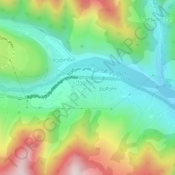
Name: Kvesheti topographic map, elevation, terrain.
Location: Kvesheti, Dusheti Municipality, Mtskheta-Mtianeti, Georgia (42.42271 44.55166 42.42848 44.56790)
Average elevation: 1,491 m
Minimum elevation: 1,286 m
Maximum elevation: 1,872 m
Thank you for supporting this site ❤️
Make a donation
Make a donation
Gear up for your next adventure:
As an Amazon Associate, this site earns from qualifying purchases at no extra cost to you.