
Yeongju-si topographic map
Interactive map
Click on the map to display elevation.
About this map
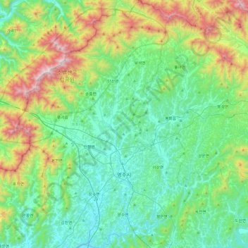
Name: Yeongju-si topographic map, elevation, terrain.
Location: Yeongju-si, North Gyeongsang, South Korea (36.69520 128.42397 37.06571 128.74663)
Average elevation: 425 m
Minimum elevation: 94 m
Maximum elevation: 1,414 m
Other topographic maps
Click on a map to view its topography, its elevation and its terrain.
Changjin-dong
South Korea > Yeongju-si > Changjin-dong
Changjin-dong, Yeongju-si, Gyeongsangbuk-do, 36057, South Korea
Average elevation: 175 m