Geolocate

Maxmo topographic map

Click on the map to display elevation.

About this map

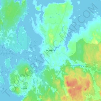
Name: Maxmo topographic map, elevation, terrain.

Location: Maxmo, Vörå, Vaasa sub-region, Ostrobothnia, Mainland Finland, 66640, Finland (63.17413 22.01561 63.25413 22.09561)

Average elevation: 9 m

Minimum elevation: -2 m

Maximum elevation: 45 m

Other topographic maps

Click on a map to view its topography, its elevation and its terrain.

Korsnäs

Finland > Ostrobothnia

Average elevation: 11 m

Vaasa

Finland > Ostrobothnia

Average elevation: 11 m

Nykarleby

Finland > Ostrobothnia

Average elevation: 16 m

Vaasa

Finland > Ostrobothnia

Average elevation: 11 m

Isolahti

Finland > Ostrobothnia > Vaasa

Average elevation: 7 m

Jakobstad

Finland > Ostrobothnia

Average elevation: 6 m

Larsmo

Finland > Ostrobothnia

Average elevation: 10 m

Sundom

Finland > Ostrobothnia > Vaasa

Average elevation: 7 m

Kristinestad

Finland > Ostrobothnia

Average elevation: 28 m

Nykarleby

Finland > Ostrobothnia

Average elevation: 16 m

Vörå

Finland > Ostrobothnia

The name Vörå was first mentioned in documents in 1367 and the parish of Vörå was first mentioned in 1443. The parish name has been the subject of both historical and toponymy research since at least 1734. It has been debated whether the name is originally Swedish Vörå or Finnish Vöyri and what the…

Average elevation: 15 m

Jakobstad

Finland > Ostrobothnia

Average elevation: 6 m

Gear up for your next adventure:

Lightweight Solo Tents - Backpacking tents designed for wild camping in the UK highlands
🧢Thermal Beanie Hats - Prevent heat loss from the head in windy summit conditions
🔦LED Camping Lanterns - Illumination for reading maps inside your tent at night
🔦Outdoor Torches - Reliable torches for night navigation
📱Rugged Phone Cases - Heavy-duty protection for smartphones used as secondary GPS tools

As an Amazon Associate, this site earns from qualifying purchases at no extra cost to you.