
Grünburg topographic map
Interactive map
Click on the map to display elevation.
About this map
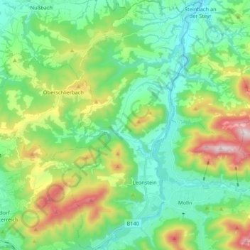
Name: Grünburg topographic map, elevation, terrain.
Location: Grünburg, Bezirk Kirchdorf, Oberösterreich, 4594, Österreich (47.86562 14.18347 47.97491 14.26791)
Average elevation: 607 m
Minimum elevation: 342 m
Maximum elevation: 1,258 m
Other topographic maps
Click on a map to view its topography, its elevation and its terrain.
Spital am Pyhrn
Österreich > Oberösterreich > Bezirk Kirchdorf
Spital am Pyhrn, Bezirk Kirchdorf, Oberösterreich, 4582, Österreich
Average elevation: 1,106 m
Rosenau am Hengstpaß
Österreich > Oberösterreich > Bezirk Kirchdorf
Rosenau am Hengstpaß, Bezirk Kirchdorf, Oberösterreich, 4581, Österreich
Average elevation: 1,043 m
Karlspitze
Österreich > Oberösterreich > Bezirk Kirchdorf > Hinterstoder
Karlspitze, Hinterstoder, Bezirk Kirchdorf, Oberösterreich, 4573, Österreich
Average elevation: 1,377 m
Hutterer Böden
Österreich > Oberösterreich > Bezirk Kirchdorf > Hinterstoder
Hutterer Böden, Hinterstoder, Bezirk Kirchdorf, Oberösterreich, 4573, Österreich
Average elevation: 1,327 m
Steyr
Österreich > Oberösterreich > Bezirk Kirchdorf
Steyr, Bezirk Kirchdorf, Oberösterreich, 4523, Österreich
Average elevation: 809 m
Micheldorf in Oberösterreich
Österreich > Oberösterreich > Bezirk Kirchdorf > Micheldorf in Oberösterreich
Micheldorf in Oberösterreich, Bezirk Kirchdorf, Oberösterreich, 4563, Österreich
Average elevation: 679 m
Kirchdorf an der Krems
Österreich > Oberösterreich > Bezirk Kirchdorf
Kirchdorf an der Krems, Bezirk Kirchdorf, Oberösterreich, 4560, Österreich
Average elevation: 475 m
Steyrling
Österreich > Oberösterreich > Bezirk Kirchdorf > Steyrling
Steyrling, Klaus an der Pyhrnbahn, Bezirk Kirchdorf, Oberösterreich, 4564, Österreich
Average elevation: 757 m
Leonstein
Österreich > Oberösterreich > Bezirk Kirchdorf > Grünburg > Leonstein
Leonstein, Grünburg, Bezirk Kirchdorf, Oberösterreich, 4594, Österreich
Average elevation: 531 m