
Make a donation
Gear up for your next adventure:
As an Amazon Associate, this site earns from qualifying purchases at no extra cost to you.
Chapel Row topographic map
Click on the map to display elevation.
Make a donation
Gear up for your next adventure:
As an Amazon Associate, this site earns from qualifying purchases at no extra cost to you.
About this map
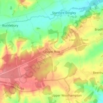
Name: Chapel Row topographic map, elevation, terrain.
Average elevation: 96 m
Minimum elevation: 54 m
Maximum elevation: 137 m
West Berkshire trails, hiking, mountain biking, running and outdoor activities
Make a donation
Gear up for your next adventure:
As an Amazon Associate, this site earns from qualifying purchases at no extra cost to you.
Other topographic maps
Click on a map to view its topography, its elevation and its terrain.
Make a donation
Gear up for your next adventure:
As an Amazon Associate, this site earns from qualifying purchases at no extra cost to you.
Newbury
United Kingdom > England > West Berkshire
Elevations vary from a minimum of 72 m above mean sea level to 122 m at Wash Common. Elevations reach 150–200 m in the directly adjoining hills. The River Kennet and the Kennet and Avon Canal flow east through the centre of the town to reach the Thames at Reading, while the River Lambourn (beside which is…
Average elevation: 97 m
Make a donation
Gear up for your next adventure:
As an Amazon Associate, this site earns from qualifying purchases at no extra cost to you.
Make a donation
Gear up for your next adventure:
As an Amazon Associate, this site earns from qualifying purchases at no extra cost to you.
Make a donation
Gear up for your next adventure:
As an Amazon Associate, this site earns from qualifying purchases at no extra cost to you.
Streatley
United Kingdom > England > West Berkshire
Streatley is a village and civil parish on the River Thames in Berkshire, England. The village faces Goring-on-Thames. The two places share in their shops, services, leisure, sports and much of their transport. Across the river is Goring & Streatley railway station and the village cluster adjoins a lock and…
Average elevation: 95 m
Make a donation
Gear up for your next adventure:
As an Amazon Associate, this site earns from qualifying purchases at no extra cost to you.
Make a donation
Gear up for your next adventure:
As an Amazon Associate, this site earns from qualifying purchases at no extra cost to you.
Make a donation
Gear up for your next adventure:
As an Amazon Associate, this site earns from qualifying purchases at no extra cost to you.
Compton
United Kingdom > England > West Berkshire
Compton is buffered from neighbouring settlements by cultivated fields to all sides. The village is in a gently-sloped dry valley and the fledgling Pang seasonally enters from the north west and discharges in the south east and may be joined at the centre of the village by the Roden from the north, when winter…
Average elevation: 137 m
Make a donation
Gear up for your next adventure:
As an Amazon Associate, this site earns from qualifying purchases at no extra cost to you.
Make a donation
Gear up for your next adventure:
As an Amazon Associate, this site earns from qualifying purchases at no extra cost to you.
Make a donation
Gear up for your next adventure:
As an Amazon Associate, this site earns from qualifying purchases at no extra cost to you.
Make a donation
Gear up for your next adventure:
As an Amazon Associate, this site earns from qualifying purchases at no extra cost to you.
Make a donation
Gear up for your next adventure:
As an Amazon Associate, this site earns from qualifying purchases at no extra cost to you.
Make a donation
Gear up for your next adventure:
As an Amazon Associate, this site earns from qualifying purchases at no extra cost to you.
Compton
United Kingdom > England > West Berkshire
Compton is buffered from neighbouring settlements by cultivated fields to all sides. The village is in a gently sloped dry valley and the fledgling Pang seasonally enters from the north west and discharges in the south east and may be joined at the centre of the village by the Roden from the north, when winter…
Average elevation: 137 m
Newbury
United Kingdom > England > West Berkshire
Elevations vary from a minimum of 72 m above mean sea level to 122 m at Wash Common. Elevations reach 150–200 m in the directly adjoining hills. The River Kennet and the Kennet and Avon Canal flow east through the centre of the town to reach the Thames at Reading, while the River Lambourn (beside which is…
Average elevation: 97 m
Make a donation
Gear up for your next adventure:
As an Amazon Associate, this site earns from qualifying purchases at no extra cost to you.
Newbury
United Kingdom > England > West Berkshire
Elevations vary from a minimum of 72 m above mean sea level to 122 m at Wash Common. Elevations reach 150–200 m in the directly adjoining hills. The River Kennet and the Kennet and Avon Canal flow east through the centre of the town to reach the Thames at Reading, while the River Lambourn (beside which is…
Average elevation: 97 m