Geolocate

Butler topographic map

Click on the map to display elevation.

About this map

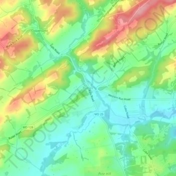
Name: Butler topographic map, elevation, terrain.

Location: Butler, Baltimore County, Maryland, 21023, United States (39.51454 -76.74764 39.55454 -76.70764)

Average elevation: 134 m

Minimum elevation: 88 m

Maximum elevation: 207 m

Gear up for your next adventure:

🧴Tick Removal Tools - Small, essential health tool for UK woodland and moorland
🥾Hiking Boot Waterproofing Wax - Maintain the lifespan of your leather trekking boots
📕Outdoor Navigation Books - Learn traditional and modern navigation techniques
🧊Insulated Flasks - Keeps drinks hot or cold during hikes
📷Outdoor Action Cameras - Cameras designed for hiking and adventure

As an Amazon Associate, this site earns from qualifying purchases at no extra cost to you.