Geolocate

Locust Dale topographic map

Click on the map to display elevation.

About this map

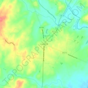
Name: Locust Dale topographic map, elevation, terrain.

Location: Locust Dale, Madison County, Virginia, 22948, United States (38.31624 -78.14695 38.35624 -78.10695)

Average elevation: 116 m

Minimum elevation: 89 m

Maximum elevation: 156 m

Other topographic maps

Click on a map to view its topography, its elevation and its terrain.

Rapidan River

United States > Virginia > Madison County

Average elevation: 125 m

Gear up for your next adventure:

🛰️Handheld GPS Devices - Reliable GPS units for hiking and outdoor navigation
🧼Technical Clothing Wash - Special soap to clean and restore waterproof membranes
🥾Men's Waterproof Hiking Boots - Durable footwear with deep lugs for muddy and rocky UK terrains
🔋Solar Chargers - Eco-friendly charging solutions for outdoor use
🔭Compact Hiking Binoculars - Lightweight optics for scouting terrain and spotting wildlife

As an Amazon Associate, this site earns from qualifying purchases at no extra cost to you.