
Make a donation
Gear up for your next adventure:
As an Amazon Associate, this site earns from qualifying purchases at no extra cost to you.
Peace River topographic map
Click on the map to display elevation.
Make a donation
Gear up for your next adventure:
As an Amazon Associate, this site earns from qualifying purchases at no extra cost to you.
Peace River
Physiographically, the Town of Peace River lies within the Peace River Formation, a stratigraphical unit of middle Albian age in the Western Canadian Sedimentary Basin. The area developed on sediments of the former lake bottom of Glacial Lake Peace, which covered most of the areas in the region that were below 610 m in elevation.
Make a donation
Gear up for your next adventure:
As an Amazon Associate, this site earns from qualifying purchases at no extra cost to you.
About this map
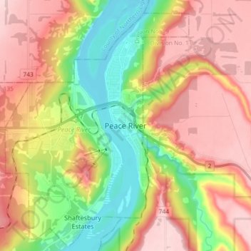
Name: Peace River topographic map, elevation, terrain.
Location: Peace River, Alberta, T8S 1P7, Canada (56.19371 -117.33108 56.27371 -117.25108)
Average elevation: 433 m
Minimum elevation: 308 m
Maximum elevation: 551 m
Make a donation
Gear up for your next adventure:
As an Amazon Associate, this site earns from qualifying purchases at no extra cost to you.