
Make a donation
Gear up for your next adventure:
As an Amazon Associate, this site earns from qualifying purchases at no extra cost to you.
Dezful topographic map
Click on the map to display elevation.
Make a donation
Gear up for your next adventure:
As an Amazon Associate, this site earns from qualifying purchases at no extra cost to you.
Dezful
Dezful is 650 kilometers away from the national capital of Tehran and 155 kilometres away from the provincial capital of Ahvaz. The city is located 300 kilometres from the Persian Gulf and is at an altitude of 143 meters.
Make a donation
Gear up for your next adventure:
As an Amazon Associate, this site earns from qualifying purchases at no extra cost to you.
About this map
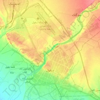
Name: Dezful topographic map, elevation, terrain.
Location: Dezful, بخش مرکزی, Dezful County, Khuzestan Province, Iran (32.34519 48.34017 32.45861 48.48374)
Average elevation: 137 m
Minimum elevation: 105 m
Maximum elevation: 169 m
Make a donation
Gear up for your next adventure:
As an Amazon Associate, this site earns from qualifying purchases at no extra cost to you.
Other topographic maps
Click on a map to view its topography, its elevation and its terrain.
دره ارواح
Iran > Khuzestan Province > Dezful County > دهستان شهی > Bisheh Bozān
Average elevation: 593 m