
Misty River topographic map
Interactive map
Click on the map to display elevation.
About this map
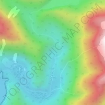
Name: Misty River topographic map, elevation, terrain.
Average elevation: 378 m
Minimum elevation: 0 m
Maximum elevation: 1,102 m
Other topographic maps
Click on a map to view its topography, its elevation and its terrain.
Sutherland Falls
New Zealand > Southland > Southland District > Fiordland Community
Sutherland Falls, Fiordland Community, Southland District, Southland, New Zealand
Average elevation: 1,006 m
Mount Mackenzie
New Zealand > Southland > Southland District > Fiordland Community
Mount Mackenzie, Fiordland Community, Southland District, Southland, New Zealand
Average elevation: 1,170 m
Milford Sound
New Zealand > Southland > Southland District > Fiordland Community
Milford Sound, Fiordland Community, Southland District, Southland, New Zealand
Average elevation: 655 m
Turner Falls
New Zealand > Southland > Southland District > Fiordland Community
Turner Falls, Fiordland Community, Southland District, Southland, New Zealand
Average elevation: 1,335 m
Manapouri
New Zealand > Southland > Southland District > Fiordland Community > Manapouri
Manapouri, Fiordland Community, Southland District, Southland, 7969, New Zealand
Average elevation: 213 m
Te Anau
New Zealand > Southland > Southland District > Fiordland Community
Te Anau, Fiordland Community, Southland District, Southland, 9600, New Zealand
Average elevation: 249 m