
Make a donation
Gear up for your next adventure:
As an Amazon Associate, this site earns from qualifying purchases at no extra cost to you.
Penrith topographic map
Click on the map to display elevation.
Make a donation
Gear up for your next adventure:
As an Amazon Associate, this site earns from qualifying purchases at no extra cost to you.
About this map
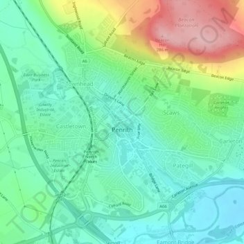
Name: Penrith topographic map, elevation, terrain.
Location: Penrith, Westmorland and Furness, England, United Kingdom (54.65342 -2.77499 54.67625 -2.72425)
Average elevation: 164 m
Minimum elevation: 108 m
Maximum elevation: 281 m
Make a donation
Gear up for your next adventure:
As an Amazon Associate, this site earns from qualifying purchases at no extra cost to you.
Other topographic maps
Click on a map to view its topography, its elevation and its terrain.
Milburn
United Kingdom > England > Westmorland and Furness
From an agricultural perspective, however, the Geopark is simply an area of poorly drained grazing that becomes progressively less useful as its altitude increases. Nevertheless, the lower slopes of the inlier are still sufficiently valuable to be enclosed, largely with drystone walling, and are used for…
Average elevation: 320 m
Crosby Ravensworth
United Kingdom > England > Westmorland and Furness > Crosby Ravensworth
Average elevation: 261 m
Make a donation
Gear up for your next adventure:
As an Amazon Associate, this site earns from qualifying purchases at no extra cost to you.
Kearstwick
United Kingdom > England > Westmorland and Furness > South Lakeland > Kirkby Lonsdale
Average elevation: 95 m
Make a donation
Gear up for your next adventure:
As an Amazon Associate, this site earns from qualifying purchases at no extra cost to you.
Isle of Walney
United Kingdom > England > Westmorland and Furness > Barrow-in-Furness > Biggar
Average elevation: 8 m
Make a donation
Gear up for your next adventure:
As an Amazon Associate, this site earns from qualifying purchases at no extra cost to you.
Hincaster
United Kingdom > England > Westmorland and Furness > South Lakeland > Hincaster
Average elevation: 51 m