
Ixtapaluca topographic map
Interactive map
Click on the map to display elevation.
About this map
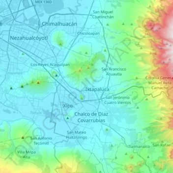
Name: Ixtapaluca topographic map, elevation, terrain.
Location: Ixtapaluca, État de Mexico, 56535, Mexique (19.15710 -99.06501 19.47710 -98.74501)
Average elevation: 2,440 m
Minimum elevation: 2,223 m
Maximum elevation: 3,787 m
Other topographic maps
Click on a map to view its topography, its elevation and its terrain.
Jorge Jiménez Cantú
Mexique > État de Mexico > Ixtapaluca > Jorge Jiménez Cantú
Jorge Jiménez Cantú, Ixtapaluca, État de Mexico, 56530, Mexique
Average elevation: 2,307 m