
Province of Oxapampa topographic map
Interactive map
Click on the map to display elevation.
Province of Oxapampa
Oxapampa is the largest of three provinces that make up the Pasco Region in Peru. The capital of the province is the city of Oxapampa. The province is located on the eastern slopes of the Andes reaching down to the lowlands of the Amazon Basin. The high point of the province is approximately 5,300 metres (17,400 ft) in elevation near the summit of Huaguruncho mountain in the Huancabamba District and the low point is approximately 200 metres (660 ft) on the Pachitea River in the Constitución District.
About this map
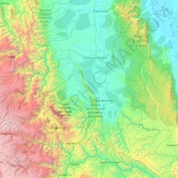
Name: Province of Oxapampa topographic map, elevation, terrain.
Location: Province of Oxapampa, Pasco, Peru (-10.91260 -75.98550 -9.44570 -74.13203)
Average elevation: 1,348 m
Minimum elevation: 152 m
Maximum elevation: 5,332 m
Other topographic maps
Click on a map to view its topography, its elevation and its terrain.
Cerro de Pasco
Cerro de Pasco is a city in central Peru, located at the top of the Andean Mountains. It is the capital of both the Pasco Province and the Department of Pasco, and an important mining center of silver, copper, zinc and lead. At an elevation of 4,330 metres (14,210 ft), it is one of the highest cities in the…
Average elevation: 4,239 m