
Oberzissen topographic map
Interactive map
Click on the map to display elevation.
About this map
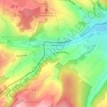
Name: Oberzissen topographic map, elevation, terrain.
Average elevation: 285 m
Minimum elevation: 202 m
Maximum elevation: 370 m
Eine Höhenburg mit wechselvoller Geschichte ist die Ruine der Burg Olbrück oberhalb von Oberzissen, wahrscheinlich um 1050 gegründet und 1112 erstmals urkundlich erwähnt.
Other topographic maps
Click on a map to view its topography, its elevation and its terrain.
Eifel
Deutschland > Rheinland-Pfalz > Landkreis Ahrweiler > Adenau
Eifel, Adenau, Landkreis Ahrweiler, Rheinland-Pfalz, Deutschland
Average elevation: 585 m