
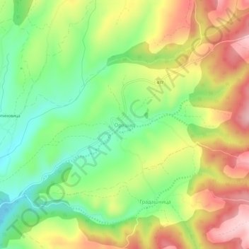
Orasac topographic map
Interactive map
Click on the map to display elevation.
About this map
Name: Orasac topographic map, elevation, terrain.
Average elevation: 389 m
Minimum elevation: 264 m
Maximum elevation: 542 m
Other topographic maps
Click on a map to view its topography, its elevation and its terrain.
Leskovac
Serbia > Central Serbia > Jablanica Administrative District
Leskovac is situated in the heart of the vast and fertile valley of Leskovac (50 km (31 mi) long and 45 km (28 mi) wide), the small Veternica river, at the foot of Hisar, in the central part of the Leskovac valley. Leskovac lies at an altitude of 228 meters, in a basin that covers 2,250 km2 (869 sq mi). Around…
Average elevation: 237 m
Stajkovce
Serbia > Central Serbia > Jablanica Administrative District > Vlasotince Municipality
Average elevation: 285 m
Kapit
Serbia > Central Serbia > Jablanica Administrative District > Medvedja Municipality
Average elevation: 522 m