
Make a donation
Gear up for your next adventure:
As an Amazon Associate, this site earns from qualifying purchases at no extra cost to you.
Cairo topographic map
Click on the map to display elevation.
Make a donation
Gear up for your next adventure:
As an Amazon Associate, this site earns from qualifying purchases at no extra cost to you.
About this map
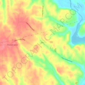
Name: Cairo topographic map, elevation, terrain.
Location: Cairo, Limestone County, Alabama, United States (34.85064 -87.16446 34.89064 -87.12446)
Average elevation: 214 m
Minimum elevation: 169 m
Maximum elevation: 246 m
Make a donation
Gear up for your next adventure:
As an Amazon Associate, this site earns from qualifying purchases at no extra cost to you.
Other topographic maps
Click on a map to view its topography, its elevation and its terrain.
Lake Ida
United States > Alabama > Limestone County > Athens > Lake Ida Heights
Average elevation: 218 m
Make a donation
Gear up for your next adventure:
As an Amazon Associate, this site earns from qualifying purchases at no extra cost to you.
Lake Ida
United States > Alabama > Limestone County > Athens > Lake Ida Heights
Average elevation: 217 m