
Santa Cruz topographic map
Interactive map
Click on the map to display elevation.
Santa Cruz
Santa Cruz is traversed by mountain ranges and high relief that include part of Mount Apo, the highest mountain peak in the Philippines, straddle the south, central, north and north-western portions of the municipality. The rugged topography of the central area gradually undulates toward the coastal plains of the north-eastern, eastern and south-eastern parts. Here, settlements sprawl contiguously along the coast of Davao Gulf under the vast monotony of coconut plantations. On the western frontier, a plateau stretches toward Barangay Kapatagan of Digos. The municipal elevation ranges from 10 to 2,939 metres (33 to 9,642 ft) above sea level (m.a.s.1.).
About this map
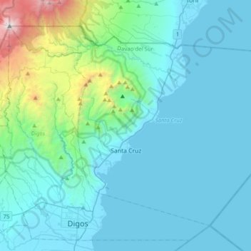
Name: Santa Cruz topographic map, elevation, terrain.
Location: Santa Cruz, Davao del Sur, Davao Region, 8001, Philippines (6.74155 125.27078 6.98719 125.58180)
Average elevation: 360 m
Minimum elevation: -4 m
Maximum elevation: 2,923 m
Other topographic maps
Click on a map to view its topography, its elevation and its terrain.
Digos
Philippines > Davao del Sur > Digos
The land topography of Digos City ranges from hilly to mountainous in the north-northeast portion and flat and slightly rolling at the coastal barangays, while the urban area and the surrounding barangays in the south portion are generally flat. Generally, climate in Digos falls under the fourth type while…
Average elevation: 152 m
Digos
The land topography of Digos City ranges from hilly to mountainous in the north-northeast portion and flat and slightly rolling at the coastal barangays, while the urban area and the surrounding barangays in the south portion are generally flat. Generally, climate in Digos falls under the fourth type while…
Average elevation: 499 m
Mount Apo
Philippines > Davao del Sur > Bansalan
Mount Apo, also known locally as Apo Sandawa, is a large solfataric, dormant stratovolcano on the island of Mindanao, Philippines. With an elevation of 2,954 meters (9,692 ft) above sea level, it is the highest-mountain in the Philippine Archipelago, Mindanao and 24th-highest peak of an island on Earth.…
Average elevation: 2,416 m