
El Aouana topographic map
Interactive map
Click on the map to display elevation.
About this map
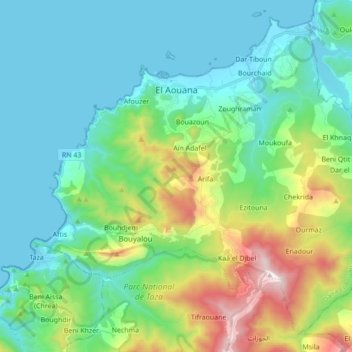
Name: El Aouana topographic map, elevation, terrain.
Location: El Aouana, Daïra El Aouana, Jijel, 18005, Algérie (36.67527 5.54021 36.80028 5.71305)
Average elevation: 263 m
Minimum elevation: -1 m
Maximum elevation: 1,107 m
El Aouana est le chef-lieu de la daïra d'El Aouana. Située à 48 mètres d’altitude entre mer et montagne, El-Aouana est accessible par route, à 70 km de Béjaïa et à 14 km de Jijel.
Other topographic maps
Click on a map to view its topography, its elevation and its terrain.
Selma Ben Ziada
Algérie > Jijel > Daïra El Aouana
Selma Ben Ziada, Daïra El Aouana, Jijel, Algérie
Average elevation: 709 m