Geolocate

Waynesville topographic map

Click on the map to display elevation.

About this map

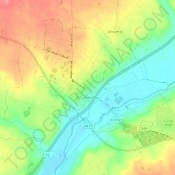
Name: Waynesville topographic map, elevation, terrain.

Location: Waynesville, Wayne Township, Warren County, Ohio, United States (39.51744 -84.11261 39.54745 -84.06312)

Average elevation: 254 m

Minimum elevation: 213 m

Maximum elevation: 301 m

Other topographic maps

Click on a map to view its topography, its elevation and its terrain.

Oregonia

United States > Ohio > Warren County

Average elevation: 271 m

Red Lion

United States > Ohio > Warren County

Average elevation: 279 m

Hicks

United States > Ohio > Warren County

Average elevation: 261 m

Roachester

United States > Ohio > Warren County

Average elevation: 241 m

Blue Ball

United States > Ohio > Warren County > Middletown

Average elevation: 224 m

Gear up for your next adventure:

🔦Outdoor Torches - Reliable torches for night navigation
🪢Paracord - Multi-purpose cord for camping and survival
🧼Camping Hygiene Kits - Compact hygiene essentials for outdoor stays
🧤Waterproof Overmitts - Extreme weather protection for hikers and mountaineers
🔋Solar Power Banks - Keep your GPS and phone charged during multi-day expeditions

As an Amazon Associate, this site earns from qualifying purchases at no extra cost to you.