
Llanvetherine topographic map
Interactive map
Click on the map to display elevation.
About this map
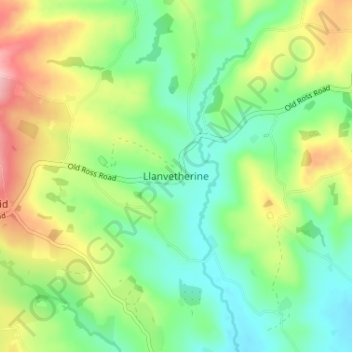
Name: Llanvetherine topographic map, elevation, terrain.
Location: Llanvetherine, Monmouthshire, Wales, NP7 8RD, United Kingdom (51.83038 -2.93946 51.87038 -2.89946)
Average elevation: 125 m
Minimum elevation: 65 m
Maximum elevation: 230 m
Other topographic maps
Click on a map to view its topography, its elevation and its terrain.
Llangwm
United Kingdom > Wales > Monmouthshire
Llangwm, Monmouthshire, Wales, NP15 1HG, United Kingdom
Average elevation: 91 m
Tintern
United Kingdom > Wales > Monmouthshire
Tintern, Monmouthshire, Wales, NP16 6SY, United Kingdom
Average elevation: 139 m
Monmouth
United Kingdom > Wales > Monmouthshire
Monmouth, Monmouthshire, Wales, NP25 3UZ, United Kingdom
Average elevation: 101 m
Abergavenny
United Kingdom > Wales > Monmouthshire > Abergavenny
Abergavenny, Monmouthshire, Wales, NP7 5NQ, United Kingdom
Average elevation: 187 m