
Tresserres topographic map
Interactive map
Click on the map to display elevation.
About this map
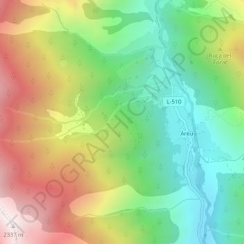
Name: Tresserres topographic map, elevation, terrain.
Average elevation: 1,650 m
Minimum elevation: 1,167 m
Maximum elevation: 2,333 m
Other topographic maps
Click on a map to view its topography, its elevation and its terrain.
Pic Verdaguer
Pic Verdaguer, Alins, Pallars-Supérieur, Lérida, Catalogne, 25574, Espagne
Average elevation: 2,746 m
Pic de Baborte
Pic de Baborte, Alins, Pallars-Supérieur, Lérida, Catalogne, 25574, Espagne
Average elevation: 2,567 m