
Crab Island topographic map
Interactive map
Click on the map to display elevation.
About this map
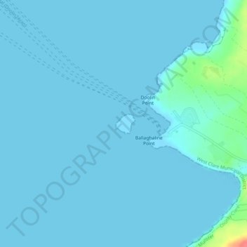
Name: Crab Island topographic map, elevation, terrain.
Location: Crab Island, Irlanda (53.01527 -9.41415 53.01738 -9.41069)
Average elevation: 4 m
Minimum elevation: 0 m
Maximum elevation: 57 m
Other topographic maps
Click on a map to view its topography, its elevation and its terrain.
The Municipal District of Kilkenny City
The Municipal District of Kilkenny City, Condado de Kilkenny, Leinster, Irlanda
Average elevation: 84 m
West Clare Municipal District
West Clare Municipal District, Condado de Clare, Munster, Irlanda
Average elevation: 37 m
The Municipal District of Naas
The Municipal District of Naas, County Kildare, Leinster, Irlanda
Average elevation: 152 m
Oldmilltown
Oldmilltown, Kilteel ED, The Municipal District of Naas, County Kildare, Leinster, Irlanda
Average elevation: 154 m
Churchtown-Orwell ED
Churchtown-Orwell ED, Dublin 14, Dún Laoghaire-Rathdown, County Dublin, Leinster, Irlanda
Average elevation: 54 m
Cherry Orchard
Cherry Orchard, Merchants Quay E ED, Dublin 8, Dublin, County Dublin, Leinster, Irlanda
Average elevation: 25 m