
Layasin topographic map
Click on the map to display elevation.
About this map
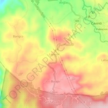
Name: Layasin topographic map, elevation, terrain.
Location: Layasin, Cavinti, Laguna, Calabarzon, 4013, Philippines (14.21391 121.47086 14.25391 121.51086)
Average elevation: 253 m
Minimum elevation: 88 m
Maximum elevation: 364 m
Other topographic maps
Click on a map to view its topography, its elevation and its terrain.
Bumbungan River
Philippines > Laguna > Cavinti
The waterfalls for which the Bumbungan river is famous is the Magdapio Falls, a section of the river in the town of Cavinti where the river drops about 300 feet (91 m). Because the original boat ride to reach the falls starts in Pagsanjan, it became known as the Pagsanjan Falls. This round trip boat ride…
Average elevation: 260 m