Steptoe Butte topographic map
Click on the map to display elevation.
About this map
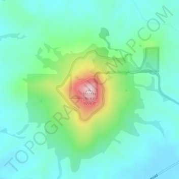
Name: Steptoe Butte topographic map, elevation, terrain.
Location: Steptoe Butte, Whitman County, Washington, United States (47.03234 -117.29718 47.03244 -117.29708)
Average elevation: 832 m
Minimum elevation: 749 m
Maximum elevation: 1,100 m
Other topographic maps
Click on a map to view its topography, its elevation and its terrain.
Pullman
United States > Washington > Whitman County
Pullman is situated within the Palouse region, characterized by its distinct topography of rolling hills formed from loess deposits—windblown silt accumulated over millennia. The city's average elevation is approximately 2,540 feet (774 meters), with elevations ranging from about 2,342 to 2,575 feet (714 to…
Average elevation: 774 m
Pullman
United States > Washington > Whitman County
The city is situated across several loess hills which characterize the Palouse Prairie, formed from windblown sediment over an estimated period of over one million years. This prairie region, the Palouse, is noteworthy for its fertile rolling hills where winter and spring wheat, barley, canola, lentils, and…
Average elevation: 774 m
Pullman
United States > Washington > Whitman County
The city is situated across several loess hills which characterize the Palouse Prairie, formed from windblown sediment over an estimated period of over one million years. This prairie region, the Palouse, is noteworthy for its fertile rolling hills where winter and spring wheat, barley, canola, lentils, and…
Average elevation: 773 m
Pullman
United States > Washington > Whitman County
The city is situated across several loess hills which characterize the Palouse Prairie, formed from windblown sediment over an estimated period of over one million years. This prairie region, the Palouse, is noteworthy for its fertile rolling hills where winter and spring wheat, barley, canola, lentils, and…
Average elevation: 774 m
Pullman
United States > Washington > Whitman County
The city is situated across several loess hills which characterize the Palouse Prairie, formed from windblown sediment over an estimated period of over one million years. This prairie region, the Palouse, is noteworthy for its fertile rolling hills where winter and spring wheat, barley, canola, lentils, and…
Average elevation: 774 m