
Preston Woods topographic map
Interactive map
Click on the map to display elevation.
About this map
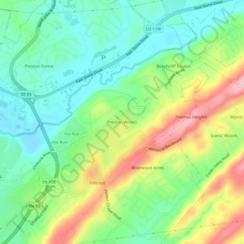
Name: Preston Woods topographic map, elevation, terrain.
Average elevation: 432 m
Minimum elevation: 362 m
Maximum elevation: 554 m
Other topographic maps
Click on a map to view its topography, its elevation and its terrain.
Fair Acres
United States > Tennessee > Sullivan County > Kingsport
Fair Acres, Kingsport, Sullivan County, East Tennessee, Tennessee, 37664, United States
Average elevation: 388 m
Gibsontown
United States > Tennessee > Sullivan County > Kingsport
Gibsontown, Kingsport, Sullivan County, East Tennessee, Tennessee, 37660, United States
Average elevation: 388 m
Brairwood Acres
United States > Tennessee > Sullivan County > Kingsport
Brairwood Acres, Kingsport, Sullivan County, Tennessee, 37664, United States
Average elevation: 450 m
Kingsport
United States > Tennessee > Sullivan County > Kingsport
Kingsport, Sullivan County, Tennessee, 37660-3610, United States
Average elevation: 474 m
Lynn Garden
United States > Tennessee > Sullivan County > Kingsport
Lynn Garden, Kingsport, Sullivan County, Tennessee, 37665, United States
Average elevation: 436 m
Beechwood Village
United States > Tennessee > Sullivan County > Kingsport
Beechwood Village, Kingsport, Sullivan County, Tennessee, 37664, United States
Average elevation: 400 m
Bloomington Heights
United States > Tennessee > Sullivan County > Kingsport
Bloomington Heights, Kingsport, Sullivan County, Tennessee, 37660, United States
Average elevation: 409 m