
Make a donation
Gear up for your next adventure:
As an Amazon Associate, this site earns from qualifying purchases at no extra cost to you.
Deer Lodge topographic map
Click on the map to display elevation.
Make a donation
Gear up for your next adventure:
As an Amazon Associate, this site earns from qualifying purchases at no extra cost to you.
About this map
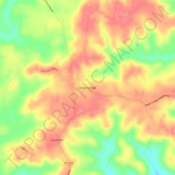
Name: Deer Lodge topographic map, elevation, terrain.
Average elevation: 466 m
Minimum elevation: 418 m
Maximum elevation: 498 m
Make a donation
Gear up for your next adventure:
As an Amazon Associate, this site earns from qualifying purchases at no extra cost to you.
Other topographic maps
Click on a map to view its topography, its elevation and its terrain.
Frozen Head State Park
United States > Tennessee > Morgan County
Frozen Head State Park consists of approximately 24,000 acres (97 km2), all but 330 acres (1.3 km2) of which is classified as a state natural area. The terrain varies between 1,300 ft (400 m) to over 3,000 ft (910 m) with 14 peaks at or over 3,000 feet (910 m). Frozen Head, the park's namesake, is the highest…
Average elevation: 579 m
Make a donation
Gear up for your next adventure:
As an Amazon Associate, this site earns from qualifying purchases at no extra cost to you.
Frozen Head State Park
United States > Tennessee > Morgan County
Frozen Head State Park consists of approximately 24,000 acres (97 km2), all but 330 acres (1.3 km2) of which is classified as a state natural area. The terrain varies between 1,300 ft (400 m) to over 3,000 ft (910 m) with 14 peaks at or over 3,000 feet (910 m). Frozen Head, the park's namesake, is the highest…
Average elevation: 579 m