
Vigueron topographic map
Interactive map
Click on the map to display elevation.
About this map
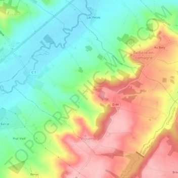
Name: Vigueron topographic map, elevation, terrain.
Average elevation: 155 m
Minimum elevation: 93 m
Maximum elevation: 232 m
Other topographic maps
Click on a map to view its topography, its elevation and its terrain.
Lauzerte
Francia > Occitania > Tarn y Garona
Lauzerte, Castelsarrasin, Tarn y Garona, Occitania, Francia metropolitana, 82110, Francia
Average elevation: 167 m
Canals
Francia > Occitania > Tarn y Garona
Canals, Montauban, Tarn y Garona, Occitania, Francia metropolitana, 82170, Francia
Average elevation: 133 m