Geolocate

Somerset topographic map

Click on the map to display elevation.

About this map
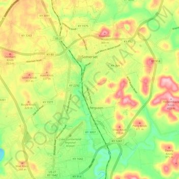
Name: Somerset topographic map, elevation, terrain.

Location: Somerset, Pulaski County, Kentucky, United States (37.03135 -84.64756 37.12006 -84.56484)

Average elevation: 295 m

Minimum elevation: 202 m

Maximum elevation: 398 m

Other topographic maps

Click on a map to view its topography, its elevation and its terrain.

Acorn

United States > Kentucky > Pulaski County

Average elevation: 345 m

Nancy

United States > Kentucky > Pulaski County

Average elevation: 312 m

Valley Oak

United States > Kentucky > Pulaski County

Average elevation: 293 m

Dykes

United States > Kentucky > Pulaski County

Average elevation: 301 m

Vanhook

United States > Kentucky > Pulaski County

Average elevation: 318 m

Nancy

United States > Kentucky > Pulaski County

Average elevation: 312 m

Gear up for your next adventure:

🎒Backpack Rain Covers - Universal waterproof covers to protect your gear from downpours
🗺️Ordnance Survey Maps - Essential paper maps for hiking across the UK national parks
🛰️Satellite Messengers - Emergency communication devices for areas without mobile signal
🔪Outdoor Multi-Tools - Versatile tools for gear repairs and food prep in the wild
🎿Telescopic Trekking Poles - Reduces knee strain on steep topographic descents

As an Amazon Associate, this site earns from qualifying purchases at no extra cost to you.