Geolocate

Pomalaa topographic map

Click on the map to display elevation.

About this map

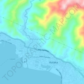
Name: Pomalaa topographic map, elevation, terrain.

Location: Pomalaa, Kolaka, Southeast Sulawesi, Sulawesi, Indonesia (-4.07000 121.58000 -4.03000 121.62000)

Average elevation: 56 m

Minimum elevation: -5 m

Maximum elevation: 305 m

Other topographic maps

Click on a map to view its topography, its elevation and its terrain.

Konaweha River

Indonesia > Southeast Sulawesi > Kolaka > Puudongi

Average elevation: 110 m

Gear up for your next adventure:

Camping Shelters - Emergency and lightweight shelters for outdoor use
🛌Sleeping Mats - Insulated mats for comfortable outdoor sleeping
🌄Outdoor Binoculars - Compact binoculars for landscape observation
🚲Cycling GPS Computers - Track elevation and topographic routes on two wheels
🍲Portable Camping Stoves - Fast-boiling stoves for hot meals on remote topographic survey trips

As an Amazon Associate, this site earns from qualifying purchases at no extra cost to you.