
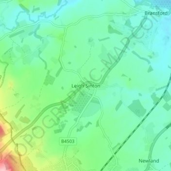
Leigh Sinton topographic map
Interactive map
Click on the map to display elevation.
About this map
Name: Leigh Sinton topographic map, elevation, terrain.
Average elevation: 56 m
Minimum elevation: 22 m
Maximum elevation: 164 m
Other topographic maps
Click on a map to view its topography, its elevation and its terrain.
Welland Stone
United Kingdom > England > Worcestershire > Malvern Hills District
Welland Stone, Malvern Hills District, Worcestershire, England, WR8 0RP, United Kingdom
Average elevation: 29 m
Newland
United Kingdom > England > Worcestershire > Malvern Hills District
Newland, Malvern Hills District, Worcestershire, England, United Kingdom
Average elevation: 48 m
Menithwood
United Kingdom > England > Worcestershire > Malvern Hills District > Menithwood
Menithwood, Pensax, Malvern Hills District, Worcestershire, England, WR6 6UH, United Kingdom
Average elevation: 122 m
Upper Wick
United Kingdom > England > Worcestershire > Malvern Hills District > Rushwick > Upper Wick
Upper Wick, Rushwick, Malvern Hills District, Worcestershire, England, WR2 5SZ, United Kingdom
Average elevation: 30 m