Geolocate

Timpson topographic map

Click on the map to display elevation.

Timpson

Lake Timpson is a reservoir in Shelby County in the state of Texas. The latitude and longitude coordinates for this reservoir are 31.8443, -94.4291 and the altitude is 318 feet (97 m).

Wikipedia (CC-BY-SA 3.0)

About this map

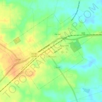
Name: Timpson topographic map, elevation, terrain.

Location: Timpson, Shelby County, Texas, 75975, United States (31.89166 -94.42145 31.91987 -94.37745)

Average elevation: 113 m

Minimum elevation: 95 m

Maximum elevation: 132 m

Other topographic maps

Click on a map to view its topography, its elevation and its terrain.

Mount Herman

United States > Texas > Shelby County

Average elevation: 124 m

Gear up for your next adventure:

🎒Hiking Backpacks - Comfortable backpacks for day hikes and multi-day treks
🔭Compact Hiking Binoculars - Lightweight optics for scouting terrain and spotting wildlife
🔦Keychain LED Torches - Emergency backup light for finding gear in your pack
🧼Technical Clothing Wash - Special soap to clean and restore waterproof membranes
🧴Tick Removal Tools - Small, essential health tool for UK woodland and moorland

As an Amazon Associate, this site earns from qualifying purchases at no extra cost to you.