
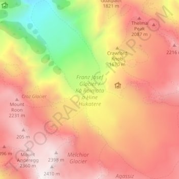
Franz Josef Glacier topographic map
Interactive map
Click on the map to display elevation.
About this map
Name: Franz Josef Glacier topographic map, elevation, terrain.
Average elevation: 1,709 m
Minimum elevation: 578 m
Maximum elevation: 2,451 m
The névé or snowfield at the head of Franz Josef Glacier is over 2,500 metres (8,200 ft) above sea level and 20 square kilometres (7.7 sq mi) in area. This wide névé, which is over 300 metres (980 ft) deep, feeds large amounts of compacted snow into a steep and narrow valley which drops quickly to very low altitudes: the glacier descends to 300 metres (980 ft) above sea level in just 11 km (6.8 mi). This combination of factors leads to Franz Josef persisting where most temperate-zone glaciers would have already melted, and allows it to share a valley with temperate rain forest.
Other topographic maps
Click on a map to view its topography, its elevation and its terrain.
De La Beche
New Zealand > West Coast > Westland District
De La Beche, Westland District, West Coast, New Zealand
Average elevation: 2,480 m
Junction Hill
New Zealand > West Coast > Westland District
Junction Hill, Westland District, West Coast, New Zealand
Average elevation: 784 m
Hidden Peak
New Zealand > West Coast > Westland District
Hidden Peak, Westland District, West Coast, New Zealand
Average elevation: 1,877 m
Haast
New Zealand > West Coast > Westland District
Haast, Westland District, West Coast, New Zealand
Average elevation: 15 m
Fox Glacier
New Zealand > West Coast > Westland District
Fox Glacier, Westland District, West Coast, New Zealand
Average elevation: 1,836 m
Amherst Glacier
New Zealand > West Coast > Westland District
Amherst Glacier, Westland District, West Coast, New Zealand
Average elevation: 1,819 m