
Make a donation
Gear up for your next adventure:
As an Amazon Associate, this site earns from qualifying purchases at no extra cost to you.
Grahams Place topographic map
Click on the map to display elevation.
Make a donation
Gear up for your next adventure:
As an Amazon Associate, this site earns from qualifying purchases at no extra cost to you.
About this map
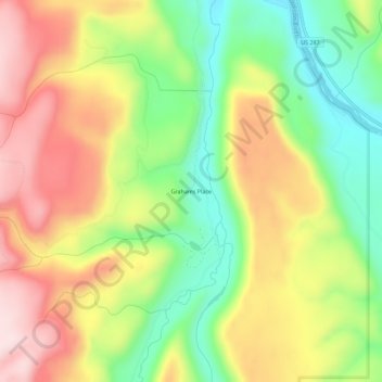
Name: Grahams Place topographic map, elevation, terrain.
Location: Grahams Place, Madison County, Montana, United States (44.83889 -111.60383 44.87889 -111.56383)
Average elevation: 1,959 m
Minimum elevation: 1,791 m
Maximum elevation: 2,140 m
Make a donation
Gear up for your next adventure:
As an Amazon Associate, this site earns from qualifying purchases at no extra cost to you.
Other topographic maps
Click on a map to view its topography, its elevation and its terrain.
Make a donation
Gear up for your next adventure:
As an Amazon Associate, this site earns from qualifying purchases at no extra cost to you.
Big Sky Dam
United States > Montana > Madison County > Big Sky > Big Sky Mountain Village
Average elevation: 2,355 m