
Anemomilia topographic map
Interactive map
Click on the map to display elevation.
About this map
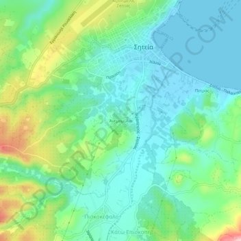
Name: Anemomilia topographic map, elevation, terrain.
Average elevation: 54 m
Minimum elevation: -1 m
Maximum elevation: 195 m
Other topographic maps
Click on a map to view its topography, its elevation and its terrain.
Agios Andreas
Greece > Region of Crete > Lasithi Regional Unit > Sitia Municipal Unit
Average elevation: 92 m
Agia Fotia
Greece > Region of Crete > Lasithi Regional Unit > Sitia Municipal Unit
Average elevation: 140 m