
Lonneker topographic map
Interactive map
Click on the map to display elevation.
About this map
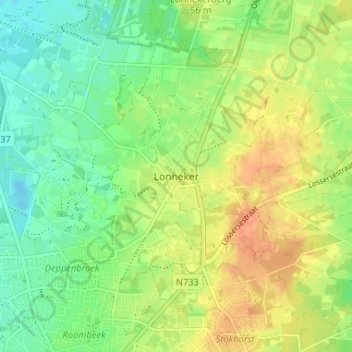
Name: Lonneker topographic map, elevation, terrain.
Location: Lonneker, Enschede, Overijssel, Nederland, 7524 CH, Nederland (52.23060 6.89174 52.27060 6.93174)
Average elevation: 47 m
Minimum elevation: 29 m
Maximum elevation: 67 m
Other topographic maps
Click on a map to view its topography, its elevation and its terrain.
Enschede
Nederland > Overijssel > Enschede
Enschede, Overijssel, Nederland, 7511GD, Nederland
Average elevation: 34 m