Geolocate

Trapene topographic map

Click on the map to display elevation.

About this map

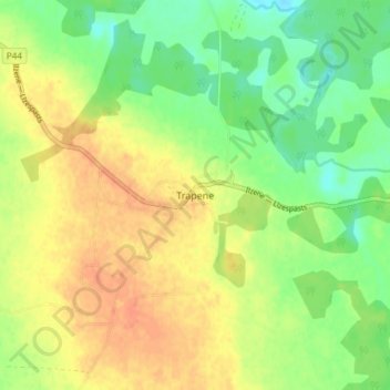
Name: Trapene topographic map, elevation, terrain.

Location: Trapene, Smiltenes novads, Vidzeme, LV-4348, Latvia (57.43028 26.57228 57.47028 26.61228)

Average elevation: 106 m

Minimum elevation: 85 m

Maximum elevation: 125 m

Other topographic maps

Click on a map to view its topography, its elevation and its terrain.

Launkalnes pagasts

Latvia > Vidzeme > Smiltenes novads

Average elevation: 153 m

Brantu pagasts

Latvia > Vidzeme > Smiltenes novads

Average elevation: 169 m

Gear up for your next adventure:

🍱Food Containers - Reusable containers for outdoor meals
🔭Compact Hiking Binoculars - Lightweight optics for scouting terrain and spotting wildlife
👟Men's Trail Running Shoes - Lightweight grip for fast movement over topographic contours
🧴Sport Sunscreen Sticks - High-protection sunblock that won't run into your eyes on the trail
🧼Camping Hygiene Kits - Compact hygiene essentials for outdoor stays

As an Amazon Associate, this site earns from qualifying purchases at no extra cost to you.