
Grand Enclos topographic map
Interactive map
Click on the map to display elevation.
About this map
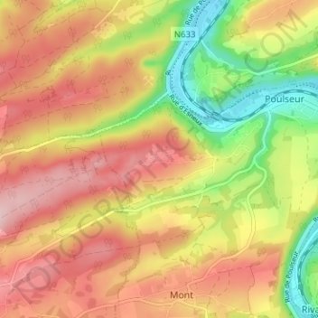
Name: Grand Enclos topographic map, elevation, terrain.
Location: Grand Enclos, Comblain-au-Pont, Liège, Wallonie, 4171, Belgique (50.48221 5.53750 50.52221 5.57750)
Average elevation: 202 m
Minimum elevation: 86 m
Maximum elevation: 295 m
Other topographic maps
Click on a map to view its topography, its elevation and its terrain.
En Sart
Belgique > Liège > Liège > Comblain-au-Pont
En Sart, Comblain-au-Pont, Liège, Wallonie, 4171, Belgique
Average elevation: 188 m
Hoyemont
Belgique > Liège > Liège > Comblain-au-Pont
Hoyemont, Comblain-au-Pont, Liège, Wallonie, 4170, Belgique
Average elevation: 212 m