
McMasterville topographic map
Interactive map
Click on the map to display elevation.
About this map
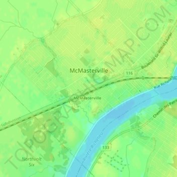
Name: McMasterville topographic map, elevation, terrain.
Average elevation: 14 m
Minimum elevation: 4 m
Maximum elevation: 18 m
Other topographic maps
Click on a map to view its topography, its elevation and its terrain.
Mont-Saint-Hilaire
Canada > Québec > La Vallée-du-Richelieu
Mont-Saint-Hilaire, La Vallée-du-Richelieu, Montérégie, Québec, Canada
Average elevation: 41 m
Beloeil
Canada > Québec > La Vallée-du-Richelieu
Beloeil, La Vallée-du-Richelieu, Montérégie, Québec, Canada
Average elevation: 40 m